Do we still have a wildlife reserve south of Mersing?
My time at the Harvard Map Collection has revealed some interesting insights on Malaysian forests. For one, what's up with the Endau Kota Tinggi Wildlife Reserve?
That area has lost two large coastal forest reserves. Added was a large forest reserve that has became a plantation of monoculture trees and oil palm. The wildlife reserve remains a puzzle.
I am somewhat familiar with that 75 km coastal belt between Mersing and Kota Tinggi in Johor. In 2020 and 2021, I have written stories for Macaranga about the impact of forest loss for the wildlife, timber industry, and communities there.
The gist: Most suffered, a few flourished. Between 2012 and 2014, the Johor government degazetted nearly 18,000 ha of the Jemaluang and Tenggaroh forest reserves. That was Johor's biggest loss in forest reserves this century. Much, if not all, of the land became privatised. Clear-cutting began a few years later to turn the natural forests into plantations and mines. Locals and wildlife, particularly elephants, became a threat to each other; sawmills and loggers paid more for timber as fewer natural forests were left to (selectively) log.
At the time, I thought Jemaluang and Tenggaroh forest reserves were just 18,000 ha large. Separately, on one map I spotted faint text indicating a wildlife reserve near the southern end of Tenggaroh. I asked around but nobody had anything concrete to add.
Did a wildlife reserve exist there?
But these couple of months at Harvard have expanded my knowledge of that area.
I have been browsing Malaysian maps in the Harvard Map Collection. One item in particular excites me: the National Atlas Malaysia (1977). Published by Dewan Bahasa dan Pustaka, this atlas has sharp maps produced by the then Department of Mapping (now Department of Survey and Mapping, JUPEM) and statistics from the Department of Statistics.
Back in the 1970s
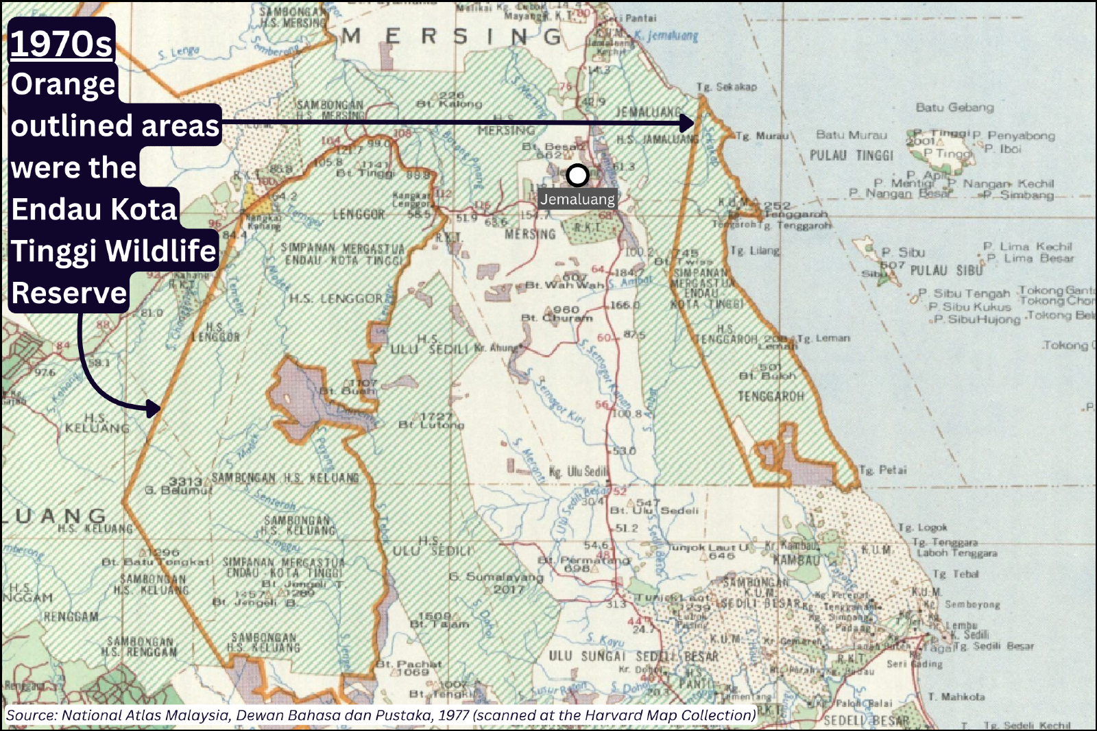
There! I beamed when I saw those two orange boxes. Indeed, Tenggaroh was once part of a wildlife reserve called "Simpanan Mergastua Endau Kota Tinggi". (Of course I had to look up 'mergastua' to know that it means 'wildlife'.) I was surprised to see that the wildlife reserve stretched up to Jemaluang.
Then my jaw dropped as I register that much larger wildlife reserve on the west nearer to Kluang.
"Oh my, the elephants and tapirs would love to roam these forests now," I thought.
I traced the forest reserves on the 1977 map using the geospatial software QGIS. I measured their areas.
My gosh! Forty years ago, the Jemaluang and Tenggaroh forest reserves were almost 38,000 ha!
How long would it take to drive around an area this large?
Half of that was gone by 2012. And by January 2015, none was left as forest reserves.
How it looks now
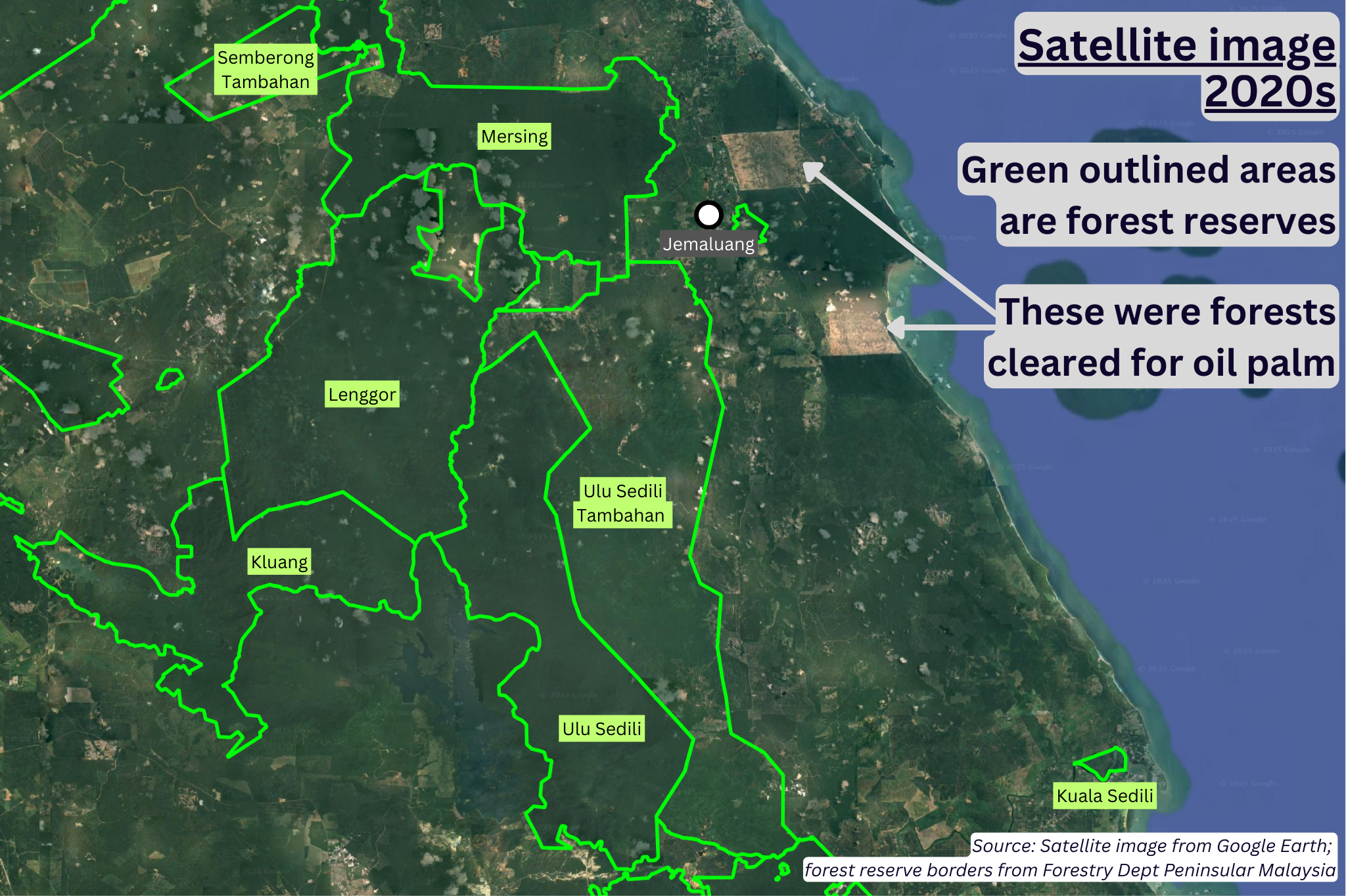
Well, the Jemaluang and Tenggaroh forest reserves are gone. (I am not so convinced that the small parcel of forest reserve east of Jemaluang town is still gazetted as one, though it shows up on the Foresty Department server as such.)
Of the 38,000 ha of natural forest in the 1970s, only 8,000 ha are left standing, sandwiched between plantations on private land.
Looking inland, approximately half of the western section of the Endau Kota Tinggi Wildlife Reserve remains as forest reserves (Lenggor and Kluang in the image above). The southern half of the Kluang forest reserve, however, has been degazetted. The Linggiu Dam was built there in the early 1990s to supply water to Singapore.
That loss from the Kluang forest reserve was "compensated" with the addition of a huge forest reserve to the east of Ulu Sedili forest reserve, called Ulu Sedili Tambahan forest reserve.
But the sprawling new Ulu Sedili Tambahan forest reserve has no natural forest.
In the satellite images above, most of Ulu Sedili Tambahan is coated in green. But it is not a natural forest. Rather, they are a blanket of fast-growing trees planted for timber – eucalyptus, acacia, rubber. Parts of the northern end of Ulu Sedili Tambahan has oil palm too. Much – perhaps all – of these sites belong to a private plantation company.
Here below is the same landscape overlaid with classifications of land cover types (by Mazur et al. 2025).
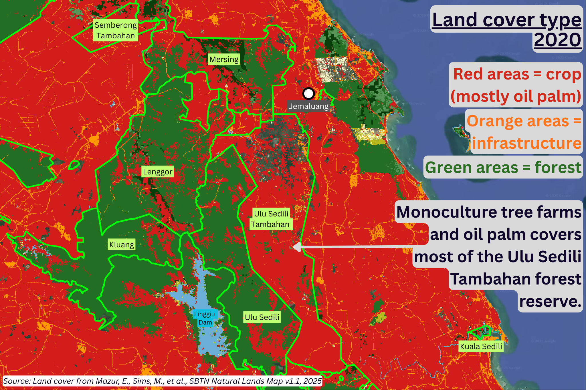
Interestingly, Mazur et al.'s modeling found considerable areas of "crops" creeping into Lenggor, Kluang and Ulu Sedili forest reserves. I suspect these are tree plantations too.
That splash of red to the west of Linggiu Dam? It was clear-cut, but I cannot confirm what is standing there now.
Here below is a sharper satellite image taken on 18 June 2025. Try to spot the areas that were cut and barren, or had regrown after clear-cutting (e.g., the west bank of the Linggiu Dam).
Endau Kota Tinggi Wildlife Reserve, you still there?
Does it still exist? I was quite confident that it's no more. And then...
A friend just pointed me to the Department of Wildlife and National Parks (PERHILITAN)'s website that lists Endau Kota Tinggi Wildlife Reserve at 43,520 ha large. (Terima kasih Kha..kawan!)
(Wow! Now I'm 100% certain the elephants and tapirs would give their trunks and snouts to find this expansive haven.)
My confidence crumbling, I searched the Internet for more evidence.
In the 2022 Central Spine Forest Masterplan (Johor) – a national project to establish a contiguous forested landscape across the peninsula – maps (pages 34-38) show the Endau Kota Tinggi Wildlife Reserve. But this time, it overlaps with the southern ends of the Ulu Sendili forest reserve and the Linggiu Dam.
Here below you can compare the 1977 map and current landscape to see what might have become of the Endau Kota Tinggi Wildlife Reserve.
The Central Spine Forest Masterplan suggests that the Endau Kota Tinggi Wildlife Reserve exists, up to 2022, at least on paper.
But if it exists, then it is unlikely to be the 43,520 ha of wildlife sanctuary where logging and development is prohibited.
Rather, it appears that it is part and parcel of existing forest reserves which can be logged. In fact, Mazur et al.'s modeling shows that clearing had already happened in southern Ulu Sedili forest reserve, which is part of the wildlife reserve, according to the Central Forest Spine Masterplan.
Update (26 Nov 2025) - More Revealed!
A reader asked if another Central Forest Spine corridor in the vicinity is also part of the Endau Kota Tinggi Wildlife Reserve. That prompted me to read the rest of the 2022 Central Forest Spine Masterplan (Johor)... and found a map that shows the entire Endau Kota Tinggi Wildlife Reserve! Thank you dear reader, for saving me from more embarrassment due to my missing that map.
New writing added below.
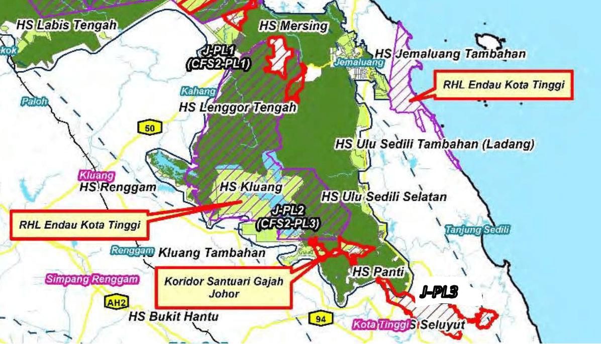
This map above gives us some important information. It also raises questions.
Now we know:
- The location of the Endau Kota Tinggi Wildlife Reserve
- It remains in two parts, as it was in the 1970s
- The wildlife reserve according to the CFS Masterplan map is about 96,000 ha large
- The western part (85,000 ha) overlaps with 3 forest reserves (Lenggor, Kluang, and Ulu Sedili)
- The eastern/coastal part (11,000 ha) sits on private land.
Then we ask:
- How is it possible to have wildlife reserve on private land (or, how can a wildlife reserve be privatised in Malaysia)
- How is it that much of the wildlife reserve has already been cleared for agriculture and other projects (see comparison below)
- PERHILITAN's list puts the wildlife reserve at 43,520 ha, which is less than half of the area (96,000 ha) indicated in the CFS Masterplan. Which is correct?
Notes:
- I'm not actively reporting now so I'm expecting mistakes in the article above. Please correct me.
- If you have tips or ideas relevant to the Endau Kota Tinggi Wildlife Reserve, please tell me. I'm curious.
- I'm sure that Arkib Negara or the National Library would have copies of the National Atlas 1977. I don't necessarily have to be at Harvard to report this. But the scanning machine at the Harvard Map Collection is great, and they appreciate my interest in their materials.